New publication!
After more busy months I can finally announce first publication stemming purely from the VIA-TARIQ project! Pažout, A. Using Archaeological Road Data to Evaluate Limits of Topography on Road Location: Roman Roads in the Near East as a Test Case. J Archaeol Method Theory 33, 28 (2026). https://doi.org/10.1007/s10816-026-09766-4 The article was published in Open Access, so you can reach it without problems on the indicated link.
The idea behind this article is quite simple: since we have digital spatially detailed and accurate data for ancient roads, we should be able to isolate the variables that influenced the location of roads in the landscape from bottom to top, using inductive approach. This sentence also explains why this was not really possible before (at least not at such a scale): until the Itiner-e was released in November 2025 there was no such dataset available for this kind of inquiry.
For starters, I am focusing only on selected topographic variables, namely slope, topographic position index (TPI), and local vector ruggeddness measure (VRML), to get a better grasp of how much do these variables contribute to the selection of where in the landscape the road will be located. This is especially interesting test case as slope is typically employed as the main variable dictating the road location and practically all least cost path algorithms are based on it.
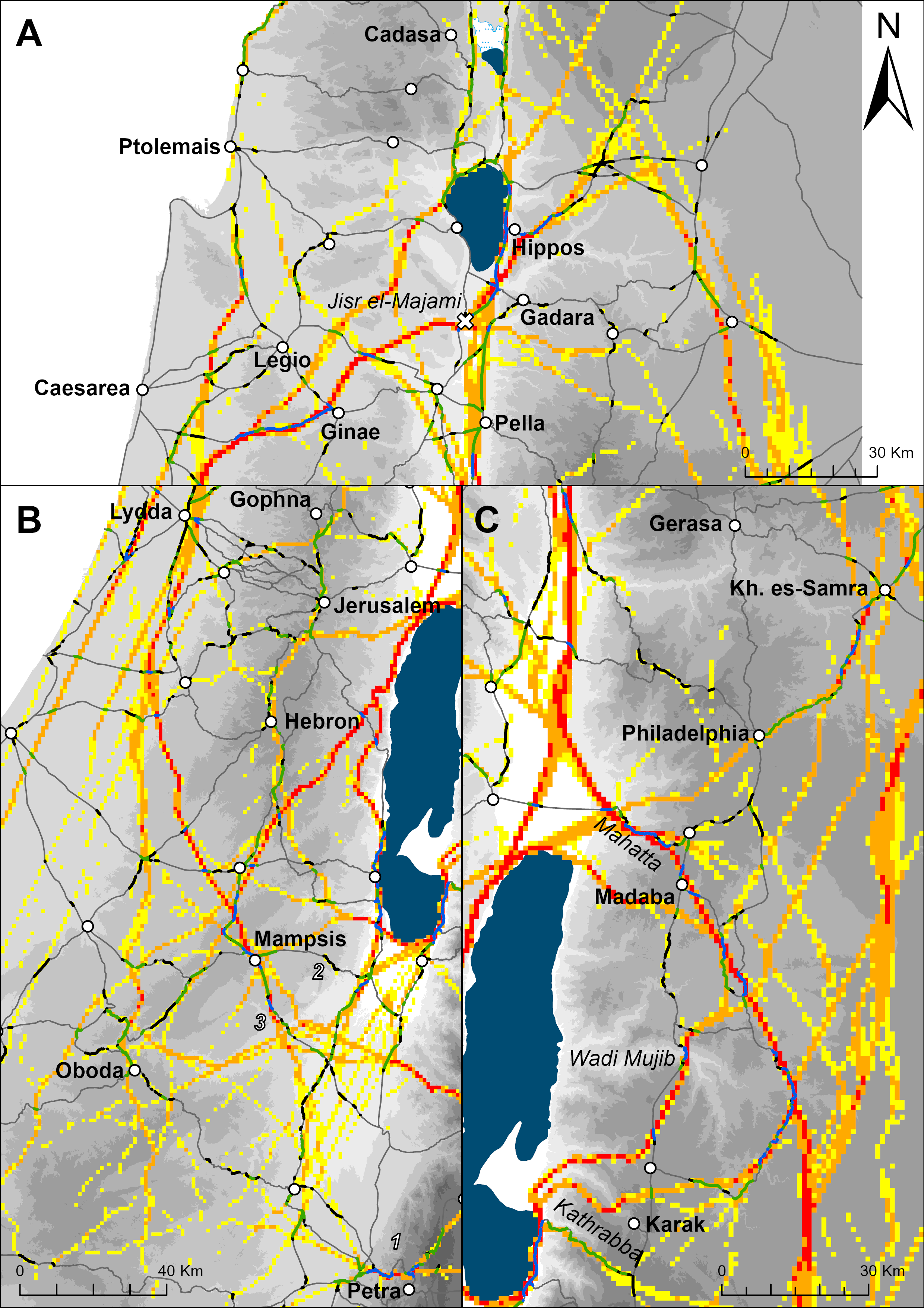
The results show that the combination of these three variables can explain around ~25% locations of the Roman roads in the southern Levant (roughly provinces Judaea and Arabia). As the picture below clearly shows, the model has more explanation power in hilly and mountainous terrain (unsurprisingly) but even here there are some significant deviations which shows that even in areas of considerable topographic variance, topography is only one of the contributing factors influencing the road location.
I am particularly happy that the model can predict well locations of quite few mountain passes but also crossings of the deep canyons in modern day Jordan (Wadi Mujib, Wadi el-Hasa). But for (semi-)desert and flat regions clearly different model would be more suitable. My thinking is going in direction of settlement structure and networks (as you could see in my previous post) and water availability, while some micro-topography features probably also played a role (but that is hard to approach using contemporary DEMs available for the regions. Well, more research is needed!
Read the rest in the article!